Standing Rock Sioux Reservation, North and South Dakota, morning and early afternoon of July 25th, 2017
I wake up at Prairie Knights Casino and Resort at the north end of Fort Yates in Standing Rock Reservation, on the North Dakota side. It’s by far the nicest place I’ve stayed during this trip and one of the cheapest. Thanks, gamblers, for subsidizing my roomy bed, my nice bathtub with its complimentary tasty-smelling chokecherry bath products, and my ultra-clean room!
I head south on Highway 1806, otherwise known as the Native American Scenic Byway, towards the tiny unincorporated community of Kenel, in search of the site of old Fort Manuel. Counting from the road just across from Kenel’s general store, I turn left on the third road, a dirt road, guided by a little brown road sign. Then I head straight, past the turnoff that curves off to the left back towards Kenel. After a little while, this road curves to the left as well and arrives at a simple, tall, broad gateway made of three large poles with a pair of antlers in the center of the crossbeam, indicating the entrance to someone’s private property, likely a farm or ranch. The place for which the gate marks the entry is encircled by a thick grove of trees. I pull off to the right of the road in before I reach the gateway. Then I look around and see what look like historical marker signs in the field around and beyond the left side of the wooded boundary. There are some wood structures rising from the grass beyond that. I take the little footpath heading in that direction… Read the written version here
Standing Rock Monument, Fort Yates, Standing Rock Sioux Reservation, ND. It’s a very odd monument to unfamiliar eyes: unglamorous, unprepossessing. It’s the beginning of a part of my tour where the monuments and significant places are less curated. It’s up to the looker to slow down and really look close.
Journal: Faith, South Dakota, early morning July 24th, 2017
I woke up in the backseat of the rental car this morning feeling just a little stiff. I drove late into the night last night so I could break up the long drive. I stayed alert enough to continue until a little after midnight, but then sleepiness began to give me that oddly swaying feeling; time to pull over. I chose a nice big gravel lot with a semi truck parked close to the road. I pulled into the other end of the lot near a row of colorful but rusted old tractors and other farm machinery, changed into my sleep clothes, and curled up in my backseat nest. I’ve decided to leave it ready for such impromptu car campings.
When I awoke, I stepped out to a soft cool morning. It had rained intermittently last night and there were still a few occasional drops falling. A man stepped out from a little garage in front of what I then observed was a little motel right next to the lot. He kindly invited me into the motel’s cafe for hot coffee and to freshen up, without rebuking me in word or in tone for spending the night for free right outside of his establishment. I thanked him but decided to push on. I had a little thermos with some coffee left and had felt the urge to keep going. But what a generous man! I did rebuke myself afterward for not stopping in just to show that I appreciated the invitation…. Read the written version here
Entrance to Lewis & Clark Caverns State Park, Montana. Merriwether Lewis’ and William Clark’s expedition never visited these caves: they were not discovered (by whites, anyway) until the later 1800’s. But the expedition did pass nearby, a little further south along the Jefferson River, so the caverns were later named for these intrepid explorers
In my idealistic early adulthood, I often lamented how a certain coffee chain, with its weirdly militarist logo of a two-tailed mermaid with a star on her head (the old logo was much better), seemed to crowd out much of the market for charming coffee shops serving Italian style preparations while playing quality music. The more I’ve traveled, however, the more I’ve come to appreciate their ubiquitous clean bathrooms, unlimited wifi, comfortable chairs and tables to write and read at, and dependable coffee.
Especially this morning. I woke up disheveled and a bit cramped: I camped out in the car last night on a pull-out near the road block at the very top of the pass on Beartooth Highway, which runs through the mountains of the Shoshone and Custer-Gallatin National Forests. There’s construction on the road and I made it there too late to get through; they close the top of the pass during the night so that the construction zone can be navigated safely, only in daylight hours. My decision as to where to spend the night, therefore, was made for me: every campground, lodge, and hotel I passed were full. It was too windy to set up my tent in the dark, so I re-made the nice cozy nest in the backseat that I had made the night before to spend the night in Yellowstone. I fell asleep to a spectacularly clear and starry night, and I woke up to this:… Read the written version here
Journal: Powell Campground & Lochsa Lodge, Clearwater-Nez Perce National Forest, Monday, July 17th, 2017
After lingering over breakfast this morning with my sister Bonnie, cousin Beth, nephew Cory, and cousin Mo, I realized there was no way I was making it from Spokane to Yellowstone National Park today. So I thought: why not camp near Lochsa Lodge and do the Lewis and Clark Wendover Ridge hike, which friends of mine will be doing later this week, on the way? I’ve left plenty of time in my itinerary to go spur-of-the-moment adventuring. My friends have told so many tales of joy and hardship on this hike that my curiosity and spirit of competition just can’t resist the challenge. So, I make my decision. I stop at Superior Ranger Station off I-90, discuss my plans with the two oh-so-kind and helpful women there, and get directions. The ranger here who knows the trails, as well as the ranger she conferred with by phone at Powell Ranger Station, both warn me that the trail is extremely rough and in parts nearly impassible, not having been maintained in any way for at least two years. Sounds to me right now more like a dare than a warning.
I head south on Petty Creek Road, a beautiful drive through a pastoral valley, and over the ridge to Highway 12 and a short drive back west. I was here last in snowy, frigid January. It’s very different today… Read the written version here
From time to time, I take a trip to some corner of the globe, to explore the lives and ideas of great thinkers in the places where they lived and worked. For this series, I follow in the footsteps of thinkers who are no longer alive, since those who are still telling their own stories. But those who are no longer alive in the body live on in the ideas that they pass on, and in the example they provide for us to follow.
I’m pleased and excited to announce my seventh philosophical-historical adventure: an almost three-week road trip through the Great Plains and on to Illinois. I’ll fly from Chicago to Scotland on August 9th: I’ll be pursuing a master’s degree in the history of ideas at the University of Edinburgh starting this fall. In the meantime, I’m overjoyed to have this window of time to explore parts of my country which I’ve never seen, and to learn as much as I can along the way…. Read the written version here
General store on the main road at Kenel, a community in Standing Rock Reservation, South Dakota, as seen through the windshield.
Standing Rock Sioux Reservation, North and South Dakota, morning and early afternoon of July 25th, 2017
I wake up at Prairie Knights Casino and Resort at the north end of Fort Yates in Standing Rock Reservation, on the North Dakota side. It’s by far the nicest place I’ve stayed during this trip and one of the cheapest. Thanks, gamblers, for subsidizing my roomy bed, my nice bathtub with its complimentary tasty-smelling chokecherry bath products, and my ultra-clean room!
Historical sign and wood structures near the site of old Fort Manuel, Kenel. The original site of the town
I head south on Highway 1806, otherwise known as the Native American Scenic Byway, towards the tiny unincorporated community of Kenel, in search of the site of old Fort Manuel. Counting from the road just across from Kenel’s general store, I turn left on the third road, a dirt road, guided by a little brown road sign. Then I head straight, past the turnoff that curves off to the left back towards Kenel. After a little while, this road curves to the left as well and arrives at a simple, tall, broad gateway made of three large poles with a pair of antlers in the center of the crossbeam, indicating the entrance to someone’s private property, likely a farm or ranch. The place for which the gate marks the entry is encircled by a thick grove of trees. I pull off to the right of the road in before I reach the gateway. Then I look around and see what look like historical marker signs in the field around and beyond the left side of the wooded boundary. There are some wood structures rising from the grass beyond that. I take the little footpath heading in that direction.
Portrait medallion on Sakakawea’s memorial obelisk on the west bank of the Missouri River, Standing Rock Reservation. In his record of her death, clerk John Luttig wrote: ‘She was a good and the best woman in the fort, aged about 25 years. She left a fine infant girl.’
I’m here following my trail of discovery to the site where Sakakawea lived her last year, and where she died. She was a Shoshone girl captured and enslaved by the Hidatsa people, and became one of three purchased Native American wives of an inept, and by at least one account brutish, French Canadian fur trapper named Toussaint Charbonneau. Sakakawea died at only twenty-five years of age after a long illness, probably secondary to the rigors of the Lewis and Clark expedition. During that trek, which was otherwise only undertaken by strong, travel-hardened men, she gave birth to her first child, a son, which she carried and nursed the rest of the way. Despite what would seem to us as a rather grim life story, she was loved and admired for her ability to navigate most difficulties with aplomb and for her cheerful and willing disposition. Sakakawea went on to become one of the most famous and beloved women in American history.
According to most histories, Sakakawea, sometimes spelled Sacagawea or Sakajawea (the first two are preferable because they most closely indicate the correct pronunciation in the name’s Shoshone language), died here at Fort Manuel on December 20th, 1812. There are some sources which place her death much later and far away, at the Wind River Shoshone Reservation in Wyoming on April 9th, 1884. However, that evidence is much more circumstantial and based on hearsay, and later attempts to corroborate those sources are irreconcilable with better-recorded contemporary evidence.
Reconstruction of old Fort Manuel Lisa, Kenel, South Dakota, Standing Rock Reservation
Sakakawea had moved to Fort Manuel the year before her death with her husband and a troupe of fur traders in August of 1811. Her death in December of the following year was recorded by John Luttig, clerk of the Missouri Fur Company for which the fort was founded as an outpost. This company, in turn, was founded in St. Louis in 1809 by Manuel Lisa, the Spanish entrepreneur for whom the fort was named, and William Clark was elected its president. This was the Clark of Lewis and Clark; he and Meriwether Lewis led the great exploratory expedition ordered by President Thomas Jefferson to discover a more direct trading route across the continent. From 1804 – 1806, the expedition wound northwest up the Missouri River then straight west across land to the Pacific Ocean. It was Charbonneau who was recruited by Lewis and Clark, but it was Sakakawea who lent her invaluable assistance to this mission as interpreter, trail guide, identifier of wild foods to gather, and on one occasion, rescuer of the all-important contents of a tipped boat. Clark later adopted her son, Baptiste, whom he called ‘Pomp’; he had become very fond of this tiniest member of the expedition. He later made sure Baptiste received a quality education. Charbonneau, evidently, was also rather a deadbeat.
Theodore Roosevelt Monument Manhood stone
By the way, I remember being annoyed a couple of years ago while visiting Theodore Roosevelt’s monument in Washington, D.C. Among the monument’s structures was a row of large stones engraved with quotes. On one of these, Roosevelt equates manhood with daring and courage. I commented in a piece I wrote at the time that virtues such as these are human ones, and are not distributed in human nature according to sex. Sakakawea is just one of the countless women who demonstrate this, though she performed her brave acts within a cultural milieu that inculcated these virtues primarily in men while encouraging shrinking, even shuddering, modesty in women. To be sure, she showed fear at times and wept at others. But she not only did what it was her duty to do regardless, she took on men’s duties when they weren’t fulfilling them, and then went beyond that! And she did so in a way that made others love, admire, and remember her for her ability and excellent personal qualities long after others were forgotten.
A large fireplace inside of one of Fort Manuel’s reconstructed buildings, Standing Rock, South Dakota
But back to my story… The wooden structures I see here today at Fort Manuel were built in 1965. They replaced a 1941 facsimile of the old stockade that had been built according to the details of a 1938 study of the fort’s records and of the grounds. The reconstructed stockade was not built on the exact site: its walls tracked more or less the shape of the original ones but about 6 feet away, to keep the ground open for a planned excavation that was done in 1965-1966. Fortunately, since the fort was built on high ground, it escaped the flooding of Kenel’s original location three miles north of its current site as a result of the construction of the Oahe Dam in 1944. Unfortunately, the original remains of the fort were eroded away shortly after its excavation by unusually high waves. But at least the archaeological information about the fort was retrieved before that happened. The reconstructions standing here today near the old site likely portray the original structures quite accurately, since they’re based on the very meticulous archaeological and historical research work done on the site.
View from a reconstructed building at Fort Manuel
The excavation uncovered the remains of seven structures within the original stockade walls. According to an archaeological and cultural report prepared for the U.S. Army Corps of Engineers, ‘Four of these units were dwellings (Structures A-C, E), one probably a storehouse (Structure 0), one a blacksmith shop (Structure F), and one possibly a stable or barn (Structure G). It is not known whether the post had other buildings, although extensive stripping of the site failed to reveal more. Luttig’s list of structures at the post does not tally exactly with the seven sites found by excavation and it may be incomplete.’ At first, I wonder why I see only five structures here today, but then I realize three of them are linked together like row houses, making seven in all.
Very, very few artifacts were found in the dig except for remains of the structures themselves. Fort Manuel was abandoned in the spring of 1813 after it was attacked by Native Americans allied with the British in the War of 1812. Any remaining goods were likely taken by the fort’s captors before it was burned down. Luttig, the clerk who admired Sakakawea and recorded both her death and his esteem for her; her little daughter Lizette; and her husband were among the survivors. Lizette likely died as a child, Charbonneau went on to enjoy a long life, and I don’t know what became of Luttig.
View of the Grand River from the bridge looking southwest, Standing Rock, just south of Little Eagle
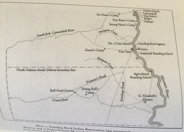
Late nineteenth-century map showing the site of Sitting Bull’s camp on the north bank of the Grand River in Standing Rock Sioux Reservation, from the papers of Francis M. Craft
Little Eagle and Bullhead on the Grand River, as shown on Google Maps, 8-13-12017. Compare the dip of the river on today’s map with the dip of the river above.
I leave Fort Manuel and head south a little ways, turn right towards Kenel Road, stop for gas and an ice cream sandwich in McLaughlin, then turn south onto Highway 63. Just south of Little Eagle, I arrive at the bridge over the Grand River, the same bridge I crossed to come to Standing Rock and Fort Yates. I pull over at the head of the bridge and stop. I have more information this time. I’m here seeking the site of Sitting Bull’s death.
Based on Francis Craft’s late nineteenth-century map, Sitting Bull’s camp was on the north bank of the Missouri River, a good ways west of it, and a little ways east of Bullhead. I compare this map with the lay of the land and water here with that as shown on Google Maps. If Bullhead and the course of the Grand River are more or less the same as they are today and this map is accurate, the site of Sitting Bull’s camp would be a little ways west of where I’m standing, near the center of the curve where the river dips south. However, when you zoom out further, the lines of the river in the old map and in Google Maps track each other only loosely. Many years and weather systems have passed and the course and flow of the Missouri River, of which the Grand River is a tributary, have been tinkered with a lot since then. The first certainly, and the second likely, would affect its course over time.
Looking north and west from the bridge over the Grand River. It was somewhere along this north bank of the river, not far from here, where Sitting Bull was killed
I think of Sitting Bull’s death… no, martyrdom; he was killed for his beliefs. His real ones, and those that others ascribed to him.
Others believed he believed in the Ghost Dance movement because he tolerated it, and that the Ghost Dance movement was really a secret plot to violently overthrow white authority because it envisioned a blessed future in which the whites couldn’t oppress Native Americans anymore. Never mind that a specific doctrine of this cult was strict non-violence. Others believed he was a threat because he didn’t believe in white people, because he didn’t trust them as they thought he should. Never mind that white soldiers and settlers had treated him and his people so badly for so long.
Sitting Bull Monument on the west bank of the Missouri River near Mobridge, SD
He believed that the world was big enough to hold many people with their different ways of living and that his people and their way of life deserved to exist, too. He believed in self-sacrifice and that convenience and luxury are not worth betraying your values for. He believed it was worth fighting the white people who were destroying his people’s ability to survive so long as it seemed there was a chance to drive them out. Then, he believed in peace when it became clear that was the only way left to survive. He believed in giving individuals, white ones too, the benefit of the doubt but he also believed you shouldn’t trust people who were crazy enough to value money and putting up fences above everything else. He believed in promises but not in written treaties: promises were the way of his people, but written treaties were invariably broken, as soon as they became inconvenient, by the very people who insisted on them.
Those are a few things I believe that he believed. I think I’m right about these, but I’m still learning, and I know there’s so much more.
I cross the bridge and continue south towards Pine Ridge Reservation, south and west of here, about a 5-hour drive.
Foley, Thomas W, ed. At Standing Rock and Wounded Knee: The Journals and Papers of Father Francis Francis M. Craft, 1888-1890. Norman: University of Oklahoma Press, 2009
Howard, Helen Addison. ‘The Mystery of Sacagawea’s Death.‘ The Pacific Northwest Quarterly, Vol. 58, No. 1 (Jan., 1967), pp. 1-6, University of Washington
Jackson, Joe. Black Elk: The Life of an American Visionary. New York: Farrar, Straus and Giroux, 2016
Standing Rock Monument, Fort Yates, Standing Rock Sioux Reservation, ND. It’s a very odd monument to unfamiliar eyes: unglamorous, unprepossessing. It’s the beginning of a part of my tour where the monuments and significant places are less curated. It’s up to the looker to slow down and really look close.
~ Dedicated to Genessa Kealoha
Journal: Faith, South Dakota, early morning July 24th, 2017
I woke up in the backseat of the rental car this morning feeling just a little stiff. I drove late into the night last night so I could break up the long drive. I stayed alert enough to continue until a little after midnight, but then sleepiness began to give me that oddly swaying feeling; time to pull over. I chose a nice big gravel lot with a semi truck parked close to the road. I pulled into the other end of the lot near a row of colorful but rusted old tractors and other farm machinery, changed into my sleep clothes, and curled up in my backseat nest. I’ve decided to leave it ready for such impromptu car campings.
When I awoke, I stepped out to a soft cool morning. It had rained intermittently last night and there were still a few occasional drops falling. A man stepped out from a little garage in front of what I then observed was a little motel right next to the lot. He kindly invited me into the motel’s cafe for hot coffee and to freshen up, without rebuking me in word or in tone for spending the night for free right outside of his establishment. I thanked him but decided to push on. I had a little thermos with some coffee left and had felt the urge to keep going. But what a generous man! I did rebuke myself afterward for not stopping in just to show that I appreciated the invitation.
Journal: Standing Rock Sioux Reservation, July 24th, 2017, later
A little less than two hours later, I reached McLaughlin, South Dakota, in the Standing Rock Sioux Reservation. At the little gas station, deli, and apparently popular gathering place, I confirmed directions to Fort Yates, another half hour northeast in the North Dakota part of the reservation.
I followed the signs to Fort Yates and to historical monuments on the main street that runs along the Missouri River. In a parking lot across from the tribal administration building, there’s a stone set upright on a pedestal of yellow-painted brick, well weathered, and some historical placards, also worn. The Standing Rock placard tells the tale of how this stone inspired the reservation’s name:
I went into the administration building and briefly described the nature of my trip. The woman at the desk directed me to the Sitting Bull Visitor Center at Sitting Bull College, up on the side of the hill above the main campus buildings. I was greeted there by Jennifer Martel, and she had much to say. Before long, it was clear to me that she’s had a long experience of feeling that she and her people are often talked at and around, that they are very frequently misrepresented and misunderstood, often because people from academia and from other cultures try to explain and portray Native American cultures in ways that make sense to themselves. That doesn’t necessarily translate into truth. It was also clear to me that this was a time to say very little, just to listen. So I did.
Lakota Winter Count (facsimile), Sitting Bull Visitor Center in Standing Rock Reservation
After we spoke for awhile, Jennifer rose to greet some people who arrived for a meeting and said she’ll keep in touch. I looked through the exhibits in the lounge area of the visitor center, then headed to the Sitting Bull College Library. I’ve just set up a little writing station where the wireless signal is best. I’ll start with asking the young lady at the desk for help….
Standing Rock Sioux Reservation, July 24th, 2017: the rest of the story
I ask the young lady at the front desk to help me find a few things I’m looking for, especially biographical information for the life and death of Sitting Bull, and especially, precisely where he died. So far, I’ve had little luck with that. She’s welcoming and friendly, and we get to talking as she begins to look through her digital and print materials. She introduces herself as Stormy, great-great (how many greats, I don’t remember) granddaughter of One Bull, nephew and adopted son of Sitting Bull. She kindly prints out maps for me to make it easier to find Sitting Bull’s monuments. After we look around for awhile, I sit down to look through what she’s given me so far while she assembles a collection of books for me. She’s friendly but not gushing, and seems like a person that would take most things in stride. I like her a lot.
Map showing the site of Sitting Bull’s camp on the north bank of the Grand River in Standing Rock Sioux Reservation, based on a late nineteenth-century map among the papers of Francis M. Craft
We continue to search our materials for information about the exact location of Sitting Bull’s death. Stormy hasn’t come up with anything so far with her online search. Among the books she gave me, I read that Sitting Bull was killed in his cabin on the Grand River ’40 miles from the Agency’, according to his biographer Stanley Vestal. The number of miles is new information for me, and I do find one more particularly helpful thing in these books: a map of Standing Rock from the late nineteenth century from the papers of Francis M. Craft, a Catholic priest who used to live here. Sitting Bull was killed on December 15, 1890, and the map shows the location of his camp on the Grand River. One of Sitting Bull’s monuments is near where the Grand River flows into the Missouri. I’ll start there so I have plenty of daytime hours to work my way west along the Grand River to seek the place where he died.
Sakakawea Memorial on the bank of the Missouri River near Sitting Bull’s memorial at Standing Rock Sioux Reservation
I make my way to Highway 1806, here called the Native American Scenic Byway, and head south towards Mobridge, short for Missouri Bridge, a little town near the monument. I cross a bridge over the Missouri River and a little island. Instead of turning left on the 12 to Mobridge, I turn right towards the casino, then left, following a roadside sign which directs me towards the Sitting Bull Memorial down a little gravel road. I park and walk down the path towards the monument site near the bank of the river. Or, rather, monuments. I didn’t know that I would find two monuments here. The first I see is an obelisk with a medallion set into it portraying a woman and an infant. My mind immediately goes to the legend of Standing Rock, of the Arikara woman and her baby who turned to stone long ago.
But across the little path that encircles the obelisk, I find a bronze plaque which tells the story of Sakakawea, who famously accompanied the Lewis and Clark Corps of Discovery and was instrumental in its success. Cartoonist Bob Thaves once joked that sure, Fred Astaire was great, but Ginger Rogers did everything he did backwards and in high heels. Sakakawea guided Meriwether Lewis, William Clark, and all their big, strong men on their grueling trail first as a pregnant teenager, then as a first-time mom caring for the newborn infant strapped to her. Not only that, she jumped into a river to rescue Lewis and Clark’s journals and other important things when their boat capsized or was about to (they named that river in her honor), found wild foods for the men to eat when their rations ran low, and in countless other ways was instrumental to the expedition’s success. She was a truly impressive person.
As I read the plaque’s brief summary of her life and death, I remember that I saw signs earlier for Kenel and Fort Manuel. I mentally add that to my itinerary for later today or early tomorrow.
Sakakawea Memorial historical plaque
After I spend a little time here, I walk further down the path towards Sitting Bull’s monument overlooking the river. This may be the site of his remains, or of some of them. He was originally buried at Fort Yates, on the other bank of the Missouri River north of here. I’ll visit that monument later today or tomorrow. There’s a story that says his remains were secreted away and buried here, closer to the place he died, away from the Agency whose overzealous Indian police killed him in a botched arrest for allegedly helping to foment Native American discontent reinvigorated by the Ghost Dance movement. The Ghost Dance was the central ritual of the quasi-Christian cult of Wovoka, a Paiute holy man. Wovoka preached that Jesus Christ would soon return to earth if the Native Americans would live lives of scrupulous virtue and perform this sacred circle dance. In the happy time of Christ’s return, the sad world of death, destruction, deprivation, and loss of liberty brought by the whites would be swept away. Health and plenty would return and the people would be joyfully united with their ancestors and dead loved ones (the ‘ghosts’).
Sitting Bull Monument near Mobridge, SD, Standing Rock Sioux Reservation
The evidence was scant indeed that this religious movement was linked to any plans for violent rebellion; indeed, one of the virtues that Wovoka called on the people to practice was total nonviolence. The evidence was also scant that Sitting Bull had much more than a tangential link to the movement. He was curious about the movement and looked into it, but didn’t become a believer. However, there seemed to him no harm in it, and its message of nonviolence accorded well with the peaceful practices of his own life subsequent to his life as a young warrior. True, Sitting Bull never trusted the U.S. government, as was fitting given the history of their encounters with his people, but he no longer advocated armed resistance. He had seen the futility of this course over his lifetime and since his people now numbered so few, his primary purpose was to see that the remainder live as best they could in this alien new world imposed upon them.
Sitting Bull Memorial plaque
The distrust between Sitting Bull and the U.S. government went both ways, however, though the military power was all on one side. Standing Rock agent James McLaughlin sent out a cadre of Native American tribal police to arrest Sitting Bull for questioning. Initially, Sitting Bull was willing to go and asked leave to get dressed first, since it was his practice to sleep without clothes. But the police were impatient and tried to force him into his clothes while restraining his hands. Some friends and family, as well as adherents of the Ghost Dance movement, observed the disturbance and came to investigate. Sitting Bull then began to resist his rude treatment and in the scuffle that ensued, shots rang out. Sitting Bull was deliberately killed by shots from two separate policemen, and all told, fifteen men died, some from each side of the fight.
Sitting Bull was killed very near the site where he was born.
Ranchland along the north bank of the Grand River
After awhile, I go back a little ways north on 1806 and turn left, or east, on the first gravel road past the dirt road that runs along the Grand River, to see what I can see. I turn left again on another road, a rougher little dirt road called 121st St, which points directly toward the river. I pass through ranchland with grazing black cattle, the river usually in sight to my left. The road dead-ends at Strong Heart Ranch. I have not gone nearly far enough to reach this site I seek, but this road places me closest to the river bank that I can reach from this side, and I want to get a feel of what the riverside scenery is like. I turn back, then turn left on the gravel road towards Wakpala. I take this road through that little town and beautiful ranch land, all the way to Highway 12. I take the 12 to Highway 63, which I take back north to Fort Yates. Little Eagle, a town near the Highway 63 bridge that crosses the Grand River further south than the 12 junction, is nearer the likely site: it’s almost 40 miles from Fort Yates, the distance specified in the old map between Fort Yates and Sitting Bull’s camp. I decide to wait until tomorrow to visit that place since I’ll be passing that town and that bridge on my way south tomorrow to my next destination.
Tipis and farmland along the Wakpala road
I return to Fort Yates and seek Sitting Bull’s original burial site, which is still perhaps the current site of his remains. Stories of his reinterment elsewhere, which I mentioned earlier, are still in dispute. I find the monument on the east bank of the Missouri River, just off Sitting Bull Ave on a wide gravel path that runs north from here along the river through a tiny park. I read the plaque, look around, then sit and think. Two Native women walk by, talking and picking up litter from the grounds. One of the women approaches and greets me. We each tell what brings us here and where we’re from. She’s lived here for most of her life, as has her shy friend. That friend smiles at me and moves off to continue her task, taking no part in the conversation. The woman who greeted me tells me what she knows of the story of Sitting Bull and of his possible reburial, and about local landmarks. She points out an area where the sage grows thickly. It’s used for sweat lodges by the men and just to crush and breathe in the scent by women because, she says, the men can handle breathing in the smoke but the women can’t ‘well, you know, because we’re women’. I smile inwardly. She has a very sturdy appearance, like she’s spent her life outdoors and working hard, and seems able to hand more physically than most women and men I know.
The other Sitting Bull memorial on the other bank of the Missouri River, Fort Yates
Sitting Bull Memorial plaque, Fort Yates
I double check with her about a good place to spend the night. She agrees with a person I spoke to earlier that day, that the lodge and casino I’ll find just a few miles north of here is the best local place to go. I head there to get a good night’s sleep and do some research for my journey tomorrow.
Foley, Thomas W, ed. At Standing Rock and Wounded Knee: The Journals and Papers of Father Francis M. Craft, 1888-1890. Norman: University of Oklahoma Press, 2009
Entrance to Lewis & Clark Caverns State Park, Montana. Merriwether Lewis’ and William Clark’s expedition never visited these caves: they were not discovered (by whites, anyway) until the later 1800’s. But the expedition did pass nearby, a little further south along the Jefferson River, so the caverns were later named for these intrepid explorers
Journal: Billings, Montana, Friday, July 21, 2017
In my idealistic early adulthood, I often lamented how a certain coffee chain, with its weirdly militarist logo of a two-tailed mermaid with a star on her head (the old logo was much better), seemed to crowd out much of the market for charming coffee shops serving Italian style preparations while playing quality music. The more I’ve traveled, however, the more I’ve come to appreciate their ubiquitous clean bathrooms, unlimited wifi, comfortable chairs and tables to write and read at, and dependable coffee.
Especially this morning. I woke up disheveled and a bit cramped: I camped out in the car last night on a pull-out near the road block at the very top of the pass on Beartooth Highway, which runs through the mountains of the Shoshone and Custer-Gallatin National Forests. There’s construction on the road and I made it there too late to get through; they close the top of the pass during the night so that the construction zone can be navigated safely, only in daylight hours. My decision as to where to spend the night, therefore, was made for me: every campground, lodge, and hotel I passed were full. It was too windy to set up my tent in the dark, so I re-made the nice cozy nest in the backseat that I had made the night before to spend the night in Yellowstone. I fell asleep to a spectacularly clear and starry night, and I woke up to this:
View from Beartooth Highway at the top of the pass on Hwy 12 through Shoshone and Custer-Gallatin National Forests, very near to where I spent the night
So I drove another hour or two until I came to Billings. I found the nearest Starbucks, took a baby-wipe-and-sink bath, brushed my teeth, changed into fresh clothes, and ordered oatmeal and coffee. Now, clean and comfortable, I’ll tell the story of my last two days on the road.
After enjoying my cold beers and a little rest at Lochsa Lodge in the early evening following my Wendover Ridge Hike in the Bitterroot Mountains on Tuesday, July 18th, I drove to Butte, Montana, where I found a cheap but perfectly acceptable motor inn which had, most importantly of all, a bathtub. The hot bath finished the restoration that dipping my arms, head, legs, and feet in the Lochsa River had begun, and I awoke the next morning ready for a long day.
On Wednesday morning, July 19th, I headed for the west entrance to Yellowstone National Park, and on my way, I noticed signs for the Lewis & Clark Caverns. I had heard of them a few times before and that they were well worth seeing. So I followed the signs, and I’m so glad I did. Here’s (some of) what I saw:
The limestone and minerals that make up most of the Caverns are colored in shades of white and gray highlighted here and there with shades of yellow and pale rust. The Paradise Room, the lowest, largest, and most colorful cave in the system, is richly hued mostly in shades of pink and purple. The lighting is carefully designed to show the colors as they would appear in daylight.
In the first of the caves, we noticed that most of the small stalactites and some of the smaller stalagmites were broken. This mangling of this natural wonder occurred in the late 1800’s and early 1900’s, when the Caverns were managed and shown to tourists by private entrepreneurs, who charged high prices and allowed visitors to break off pieces as souvenirs of their visits. This is yet one more of the hundreds of examples to show how important the national and state great public parks are. Unfortunately, profit motives and human psychology very often result in short-sighted decisions that cause long term harm, and the tragedy of the commons is revealed in the way some individuals rob the wider community of the opportunity to enjoy the riches nature has to offer unless the people unite to protect, defend, and steward them. Government, in this case as in many others, does provide an invaluable check and balance to the self-centeredness and destructiveness that form parts (but only parts) of human nature.
So I’m with documentarian Ken Burns in his belief that the National Park System (and by extension, every state and regional park system) is America’s best idea. Yellowstone, Niagara Falls, Yosemite, the Grand Canyon, Virginia’s Natural Bridge, and countless others of the most awesome, most beautiful, and most rare of the landscapes built by the forces of nature, were despoiled and marred by humans seeking to profit off these wonders regardless of whether their efforts served to protect or destroy them in the long term. Much of the damage is still being repaired if it can be at all, and some of the damage is ongoing and still unresolved as in the case of the great Yosemite Valley in my own California, where heavy car traffic is causing pollution, overcrowding, and wildlife destruction. Even good government fails sometimes, so the public needs to act as a check and balance on that as well. I would recommend that we demand that the National Park System close off Yosemite Valley to private car traffic.
Early Wednesday evening, I arrived at Yellowstone National Park, the first national park in the world (way to go, America!) and explored many of its wonders, stopping along the way to inquire at every campsite I passed whether a site had opened up. At long last, late in the evening, one did, a tiny RV site where pitching a tent is not permitted. So, I slept in the car. I felt better about that anyway, since as I was about to pull in to park, I watched a tall, thin man in a black shirt and a long black pleated glossy skirt walking slowly and deliberately backwards through my site, like a scene out of David Lynch’s Twin Peaks. I’m pretty broad-minded in my opinions of human behavior since I consider the variety and creativity in the human species among the most interesting and often delightful of natural phenomena, but this was a little weird. I let him do his thing undisturbed.
Once he left, I created a cozy sleep space in the backseat with my sleeping bag and camp sleeping pad, additionally padded at one end with my coats, towels, and sweaters, then I stepped outside, sipping from the large bottle of ale I brought with me and leaning on my rental car, looking at the brilliant stars showing between the black silhouettes of the trees. Eventually, a sustained rustle of a large creature of some sort sent me scurrying to my backseat nest. I didn’t fear bears here since the large number of other campers and their fires would keep them at bay, but the strange man had left me just a little spooked, rather to my surprise. So I laid there in the car drinking more of my ale and thinking about the amazing sights I had seen earlier that evening, only a few of which are pictured below:
Fountain Paint Pot, with intense blue above the white surrounded by brilliantly colored microbes and minerals. The water is incredibly clear and you can see the deep opening in the earth from which the water wells up
The sun sinking low over Artist’s Paint Pots, Yellowstone
I watched Old Faithful erupt for several minutes just after sunset.
The next morning, July 2oth, I explored the park. I saw wonder after wonder after wonder! Here are some of them:
Looking at the Grand Canyon of Yellowstone from the top of Lower Falls. I see where the park got its name
View of the Lower Falls from the side of the Grand Canyon of Yellowstone. I didn’t get any successful pictures of the osprey’s nest on a tower of rock near the cliff side, where the mother was guarding and feeding her two young. It was a beautiful sight to see her swoop gracefully through the air and quickly return with wiggling prey. A nature videographer on the overlook kindly let me get a few good views of the action through his camera.
A view of Yellowstone from the road between Tower / Roosevelt Junction and Mammoth Hot Springs. On recommendation, I took a brief trip to Gardiner to get water and a few supplies and to find a nearby campground to return to that night, still having no luck in Yellowstone. On the rise above Gardiner across the river and the valley between, I got these beautiful views of Yellowstone. But when it comes to a campsite, no luck here either! I shrugged my shoulders and returned to the park. Something was bound to work out… the spirit of adventure was and is strong in me, and I don’t care much where I sleep
Roosevelt Arch at the north gate of Yellowstone; I was here last this January and the backdrop was white with snow where it’s now green.
A hillside clothed in brilliant grasses and wildflowers across from the similarly garbed Mt. Washburn, Yellowstone NP
The trail up Mt Washburn, a 3-mile hike which climbs 1,400 feet
See the animals dotting the side of Mt Washburn? I saw so much wildlife up here: elk, horned mountain sheep with their young, birds, and chipmunks.
At the summit of Mt Washburn. My elation is pretty evident in this photo
The setting sun from the trail as I descended Mt Washburn
From the base of Mt Washburn, I readied myself for the drive of undetermined length from Yellowstone, Hwy 212 towards I-90 en route to my next destination via Cooke City-Silver Gate. When I was in Yellowstone in January, I saw a lot of buffalo but hadn’t seen any at all this trip. But as I drove in the dark, my headlights picked up a dark shape off to the side with two glowing eyes. I stopped and put on my hazard lights as a fuzzy, light brown, charmingly ungainly creature appeared, followed by a mother buffalo and two more calves. Over the next fifteen minutes or so, I watched a small herd of buffalo wander onto the road then mill around. Two young males found this a perfect place to tussle and push. Bison social hour was finally ended as an impatient motorist finally decided to clear the road by driving slowly at the herd, honking, until they took fright and scampered off the road. A little further on, I came across another car, pointing in the other direction, with its hazard lights on and its bumper caved in. The driver ruefully confirmed that he had collided with one of the herd, but the stricken animal was nowhere to be seen. Buffalo are hardy creatures, I hope that one recovers from the impact. Later on, my headlights picked up elk, two waddling fat little creatures (marmots?), and a red fox. As you may imagine, I drove particularly slowly after all that.
I drove on, winding up and up and up, until I reached that roadblock I told you about. I gazed at the bright, bright stars awhile, then curled up to sleep.
A view through the windshield of Petty Creek Rd / Rte 489 between I-90 and Hwy 12, Lolo National Forest, Montana
Journal: Powell Campground & Lochsa Lodge, Clearwater-Nez Perce National Forest, Monday, July 17th, 2017
After lingering over breakfast this morning with my sister Bonnie, cousin Beth, nephew Cory, and cousin Mo, I realized there was no way I was making it from Spokane to Yellowstone National Park today. So I thought: why not camp near Lochsa Lodge and do the Lewis and Clark Wendover Ridge hike, which friends of mine will be doing later this week, on the way? I’ve left plenty of time in my itinerary to go spur-of-the-moment adventuring. My friends have told so many tales of joy and hardship on this hike that my curiosity and spirit of competition just can’t resist the challenge. So, I make my decision. I stop at Superior Ranger Station off I-90, discuss my plans with the two oh-so-kind and helpful women there, and get directions. The ranger here who knows the trails, as well as the ranger she conferred with by phone at Powell Ranger Station, both warn me that the trail is extremely rough and in parts nearly impassible, not having been maintained in any way for at least two years. Sounds to me right now more like a dare than a warning.
I head south on Petty Creek Road, a beautiful drive through a pastoral valley, and over the ridge to Highway 12 and a short drive back west. I was here last in snowy, frigid January. It’s very different today.
Lochsa Lodge, Clearwater-Nez Perce National Forest, Idaho
I was in these mountains last when on a delightfully nerdy literary-historical retreat to celebrate my 40th birthday in my own way. Rather, it was just one, a newer one, of my own ways. I delight in parties, too, and in camping, and in going off on solitary adventures in which I also meet new people. On my actual 40th birthday, I went camping with a tiny company of closest family and friends, foregoing the usual New Year’s celebration with dancing, drinking, and light carousing. But I was feeling a little more pensive this time around and wanted to go off and do something on my own as well. So I went on a retreat a few weeks later which took me to Lochsa Lodge, right across the campground from where I am now, and made those very friends who will be doing the Wendover Ridge hike in a week or so. The thermometer never topped freezing when I was here last; now, it’s green and lush and warm. The campground is teeming with fat little chipmunks and birds, and the hidden animals are no doubt likewise well fed in all this abundant growth.
My tiny tent at Powell Campground, Clearwater National Forest, Idaho
The little orange tent is set up, a little green plastic doll shoe in the corner. I’ll be sleeping in my niece Savannah’s cast-off tent, very lightweight and very small. It’s sufficient for these summer days: it’s 8:30 pm as I write this and I don’t need sleeves yet. I’m using this little cast-off tent since I’ll be flying to Scotland at the end of this trip, and have no room in my luggage to take a good tent with me across the sea. It’ll go to a thrift store when I reach Chicago.
I hike trail 25, which runs north and south. I know that if I can’t find the trail or if I lose it, I could never get too lost: to the north is the top of the ridge, to the east, the West Fork of Wendover Creek and the fire road that runs along it, to the west, the other road and the steep hillside. And, of course, to the south, is the Lochsa River
Journal: Whitehouse Campground, Lolo National Forest, Idaho, July 18th, 2017
This morning, I’ll hike from the Lochsa River to Wendover Ridge, the steep 7-mile hike that those same friends I made during that January retreat call the ‘Wendover Death March.’ It follows the route (more or less) that Merriweather Lewis and William Clark took over Wendover Ridge, on a trail used by the Nez Perce, with a Shoshone guide. I’ll tell you the story tomorrow.
Trail marker for Lewis & Clark 25: 7 miles to Snowbank Camp on Wendover Ridge
Journal: Cafe at Park & Main, Butte, Montana, July 19th, 2017
From this cafe, I’ll tell the story of yesterday’s hike in annotated photos, with this introduction: relaxed from a hot bath last night, with that satisfying feeling of combined mild soreness and strength the day following strenuous exercise, a warm bowl of oatmeal and berries in my belly, a second hot cup of very creamy coffee, and the open road and adventures yet to come before my mind’s eye, I am as happy as a person can be.
This sign, not far from the trailhead, tells a bit of the Lewis & Clark story on this route
Sign marking the start of the overgrown Trail 25, Nez Perce-Clearwater National Forest
I climbed the steep first section of the trail, at times clambering over fallen trees and pushing through soft, lush, lower overgrowth, until I reached a fire road. I turned right, misreading the map, which is partially obscured by a little annotation where it portrays this section. The trail follows to the right of the road, not to the left of another which branches off, and I chose the wrong branch. I go half an hour out of my way before the sign for the Wendover Creek West Fork alerts me I’m too far east. No matter. It’s a lovely warm-up for the rigors of the next section of the hike. I go back to where I had turned onto the road and find the partially obscured trail marker which sets me on the right path again.
The butterflies are out in force in Clearwater National Forest
A cone of purple wildflowers echoes the shape of the trees on Wendover Ridge
Ah-hah, there’s the trail marker, off to the left among the tree. I was too far off to the right to notice it when I made that wrong turn.
Yes, there’s a trail under there
…. and under all that too. The trail’s overgrowth and fallen tree debris get thicker and thicker the farther I go. I should have worn pants, however warm the weather
I dub these ‘Jazz Hands Ferns’
A chipmunk tail, cleanly severed, draped decoratively on a stump. Creepy.
Hanging mosses drape a grove of trees
Another winged beauty
Thimbleberries, with a lightly sweet and tangy taste. The ripe fruit turns bright red and soft, and lifts easily off the underlying structure which it covers like a cap, or thimble. They also grow plentifully along one of my favorite hikes in the Oakland hills in California
Stunning view from the side of the ridge somewhere in the vicinity of the trail. At this point, I turned back about an hour ago. I believe I nearly reached the summit but I could not find the trail, try as I might, among the loose litter of needles in a large grove on a particularly steep section. I was nearly out of water and it was very hot: I’m still recovering from a chest inflammation and laryngitis following a particularly nasty chest cold and needed more water than usual. But the deep breathing of clean, dry, deliciously scented mountain air and strenuous exercise of the day invigorated me, and I felt better and better as I went along, nearly recovered. Still, it seemed prudent to turn back while I still had a little water, since I had hiked a long, hard distance already.
A little brook that feeds into Wendover Creek’s West Fork. Farther up, I found a large, muddy spring bubbling up over a large area; I discovered it as my shoes squelched right through it under its obscuring blanket of happy leaves. I searched and found a section where it filtered through a little patch of sand and tiny rocks. I tipped one of my canteens and pressed it gently on its side into the sand, so the water flowed into it nearly to the top. Then, I poured it into my larger canteen through my cotton shirt, filtering out most of the silt. The water was cold and minerally and incredibly refreshing. I filled the larger canteen with filtered water, and the smaller again with unfiltered. My water worry assuaged, I continued with renewed confidence. Not finding a better route down, I decided to follow the water, which I knew must inevitably lead to Wendover Creek. It was steep and required lots of sliding and Tarzaning down the slope from the overhanging strong but bendy branches
This is what a tired and very happy hiker looks like
I tore up my legs a bit on this adventure: I recommend pants despite the heat. Oh well.
I was glad to reach this fork of Wendover Creek. I was aiming for this creek since hiking downhill off-trail, which I knew was in this fold of the mountain on this side of the ridge. I finished the hike on this gravel fire road which takes me back to the main road just west of Whitehouse Pond, where I had begun the hike
One more of Nature’s winged jewels
The hike accomplished, I bathed my stinging legs and hot head and arms in the Lochsa River. What a glorious day. I completed it with two cold beers at the Lodge, a little rest, and a nice drive to Butte, Montana, and – oh, the joy – a hot bath and a long sleep. The hike took 8 1/2 hours all told, including the hour-long accidental detour.
Roosevelt Arch at the North Entrance of Yellowstone National Park. Photo: January 2017 by Amy Cools
Hello, friends of Ordinary Philosophy!
From time to time, I take a trip to some corner of the globe, to explore the lives and ideas of great thinkers in the places where they lived and worked. For this series, I follow in the footsteps of thinkers who are no longer alive, since those who are still telling their own stories. But those who are no longer alive in the body live on in the ideas that they pass on, and in the example they provide for us to follow.
I’m pleased and excited to announce my seventh philosophical-historical adventure: an almost three-week road trip through the Great Plains and on to Illinois. I’ll fly from Chicago to Scotland on August 9th: I’ll be pursuing a master’s degree in the history of ideas at the University of Edinburgh starting this fall. In the meantime, I’m overjoyed to have this window of time to explore parts of my country which I’ve never seen, and to learn as much as I can along the way.
During this journey, I’ll explore Yellowstone and the history of National Parks in America (it’s been a great NP year for me!); I’ll travel throughout the Great Plains following the history of Crazy Horse, Sitting Bull, the Lakota and their and other Native Americans’ encounters with white invaders in the 1800’s and beyond; I’ll visit Springfield, Peoria, and Chicago following Abraham Lincoln, Robert Ingersoll, uniquely American forms of art and architecture, and other topics. I’ll also make many more stops and detours along the way.
Patrons of this series: Ervin Epstein MD, Liz and Russ Eagle, Tracy Runyon, Genessa Kealoha, the Cools-Ramsden family, and Shannon Harrod Reyes ~ With warmest gratitude, thank you!


 and:
and: